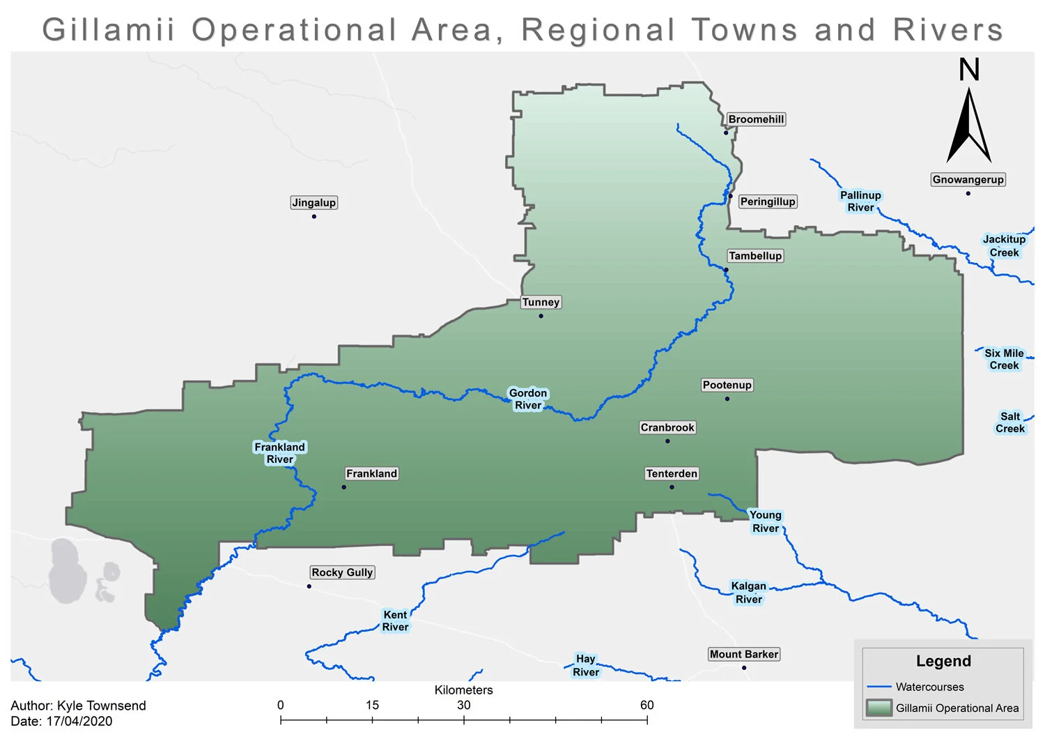
Our Subregion
The Gillamii Centre is based in the Kent Frankland subregion within the South Coast region of Western Australia, covering a total area greater than 450,000 hectares. The subregion is situated in the geographical area of the Cranbrook and Broomehill-Tambellup Shires where the upper catchment systems flow through the Gordon-Frankland River, Kent River and the internally draining local lakes system.
Catchments and Lake Systems

The Gordon River becomes the Frankland River, which eventually flows into the Nornalup Inlet on the South Coast. The catchment is 5990 square kms and encompasses 8 nationally and/or regionally significant wetland suits (systems). The Gordon River is an mature river flowing from the geological unit known as the Yilgarn Craton. The river extends between the zones of ancient and mature drainage. The Frankland River is a younger rejuvenated river channel formed during the Tertiary Period (65 to 2 million years ago).
Approximately 70-85% of the land in the Gordon-Frankland catchment is cleared agricultural land. The upper river reaches are severely degraded from the loss of fringing vegetation, bank erosion, high nutrient concentrations, sedimentation of pools and salinity. The Gordon-Frankland River and its tributaries are brackish to saline, caused by the hinterland salt lakes, saline groundwater, and increased land clearing in the catchment. The land in the upper catchment has always had a high salt content caused by the geological weathering and poor drainage, resulting in the accumulation of rain-borne salt in the deep soil profiles. Waterlogging is also a problem in the upper catchment, where drainage is slow within the broad flat terrain. Waterlogging intensifies the impact of salinity on biological communities. Land clearing has exacerbated the problem of both waterlogging and salinity.
The Kent River flows westward from headwaters in the north east near the Albany Highway at Tenterden. It changes its flow direction to southerly near Rocky Gully. The Styx River joins the Kent River before it discharges into Owingup Swamp and then into the Southern Ocean through the Irwin Inlet. The Kent River Water Resource Recovery Catchment has an area of 2170 km2 with 1092 km2 in the upper catchment (Upper Kent). The upper catchment is divided into eight management units (MUs) to reflect the changes in hydrology and land use. Three of these — Nunijup, Poorrarecup, and Nukennullup — drain into lakes and can be considered as internally draining. The flat or nearly flat ancient landscape has a weakly developed drainage pattern while the rejuvenated landscape in the south-west of the upper catchment has a well-developed dendritic drainage pattern with V-shaped valleys.
The Department of Water’s 2002 Report – Salinity Situation Statement Kent River found over the entire catchment 46% was cleared, 17% was in Blue gum plantations and 36% was native vegetation. Much like the Gordon-Frankland catchment the Upper Kent shows more severe signs degradation with similar issues of loss of fringing vegetation, bank erosion, high nutrient concentrations, sedimentation of pools and salinity.
The salt lakes of the North Stirlings, including the Balicup Lake System are thought to be ancient drainage from the Gordon River. The lakes lie between the Pallinup drainage basin and the upper Gordon catchment and then extend south to the Stirling Ranges. Most lakes drain into the Pallinup River, however unusually wet year the lakes are known to drain to the Gordon River. Therefore, Gillamii and North Stirlings Pallinup Natural Resource (Borden Landcare) have always endeavoured to work closely together to deliver Landcare works across this system.
The Balicup Lake System is one of the wetlands systems that is listed under the National Directory of Important Wetlands in Australia and consists of several wetlands, such as Lakes Balicup, Camel, and Jebarjup, occurring in small nature reserves or on private land. They are important partly because of range of species of waterbirds that they support, including some like the Banded Stilt that are protected under international treaties. Similarly, there are important wetlands in the Upper Kent catchment, such as Lake Kwornicup, that also support large numbers of waterbirds. Wetlands like Lake Nunijup and Poorrarecup are also important to the community for recreational purposes.
Climate
Our subregion is a typical Mediterranean climate with hot dry summers and cool wet winters. The highest temperatures for this region are usually experienced in the month of January.
Heat waves with temperatures exceeding 40 degrees can occur in February. The coldest temperatures are generally experienced in July.
There are several weather stations (DPIRD) throughout our subregion, the annual rainfall for 2022 was recorded at the following stations:
Tunney: 376mm
Stirlings North: 422mm
Frankland: 536.4mm
Geology and Soils
Geologically the subregion is situated between the southern edge of the Yilgarn Shield of Archaean age (>2,500 million years) and the Proterozoic rocks (600 – 2,000 million years) of the Birannup Complex to the south. The underlying basement rocks of the northern Yilgarn portion are predominantly granites, with gneisses and other high grade metamorphic rocks and quartzite forming the Biranup Complex in the south. The most significant late stage of landform development was in the Tertiary from perhaps 70 million years ago when large palaeo-channels formed, draining to the south. These filled the valleys in the underlying basement, creating the flat planar surface. Elevation of the plain is near 250 metres. The exceptions to the plains are the folded Stirling Ranges that extend as a prominent line of peaks east from Cranbrook
Although our soils are fairly infertile, the stability (lack of recent erosion) of the Yilgarn Craton has led to the subregion having many different soil types. Most of the soils comprise of deep or shallow sands over clay with gravel, grey clays and loams are also present. Summary list;
Forest Gravels
Duplex Sandy Gravels
Deep Sandy Gravels
Deep Sands
Wet Soils
Grey & Sandy Duplexes Over Clay/Gravel
Saline Wet Soils
Vegetation Type and Reserves
The vegetation of south Western Australia has a high species richness and endemism, listed as one of 35 global biodiversity hotspots. The vegetation systems that occur throughout the subregion are complex and diverse but are generally grouped into the following systems:
Jingalup System (western edge)
This vegetation system is dominated by Jarrah Marri Forest on the laterite ridges, with Jarrah and E. occidentalis and occasional Flooded Gum E. rudis in sandy alluvium. E astringens and Jarrah occur on some breakaways. A scattered understorey of sclerophyll shrub underlies the dominant species.
Kwornicup System (south west around Frankland River)
This system ccupies the swampy plain in the Frankland area that forms the interfluve between the Kent and Gordon Rivers. Jarrah Forest is often mixed with Yate Eucalyptus cornuta, Swamp Yate E. occidentalis and Wandoo E. wandoo. The small E. decipiens becomes dominant in sandy swampy places and forms Mallee communities that border lakes. Sandy swamps are dominated by Saltwater Paperbark, Melaleuca cuticularis.
Kendenup System (central south)
The vegetation system is characterized by that found on the quartzite Geekabee Hill, 15 km west of Cranbrook, where low woodlands of low Jarrah Eucalyptus marginata over a medium shrub layer occurs. E. decurva and E. macrocera occur at the base of the hill. Also known as the Darling Botanical System.
Tambellup Type of Avon System (central and northern parts)
This system consists of Wandoo E. wandoo woodland with Jarrah Woodland on laterite ridges and York Gum E. loxophleba in drainage lines and around lakes.
Tambellup Type of Roe System (east parts)
This system is also known as the Pallinup Vegetation system and consists, mainly of Mallee trees.
Stirling Range System (covering the ranges in the east)
The Stirling Range System is a highly diverse heathland containing over 1,500 species, representing 37% of the known flora of the south west of Western Australia, of which over 87 are known to be endemic to the ranges.
Reserve List:
Link to Information Library
For a complete list of flora species occurring throughout the subregion please visit Nature Map and follow the instructions
Fauna
The Shires of Cranbrook and Broomehill-Tambellup are unique as they are located at the meeting point of four bioregions. This has resulted on many different ecosystems and species coming together within a relatively small area. There are nine native animals and four birds in our operational area that are listed as rare or threatened:
Woylie
Chuditch
Bilby
Numbat
Western Barred Bandicoot
Red-tailed Phascogale
Western Ringtail Possum
Quokka
Red-tailed Black Cockatoo
Baudin’s Cockatoo
Carnaby’s Black Cockatoo
Malleefowl
There are many other native animals in our region which are not listed as threatened. These include geckoes, frogs, lizards, dragons, bats, skins, dunarts, boodies, pygmy and honey possums, kangaroos, emus, and many birds.
For a complete list of fauna species occurring throughout the subregion please visit Nature Map and follow the instructions
Nyungar History and Culture
The South West of Australia forms the distinct cultural block defined by the distribution of the Nyungar language. Our subregion encompasses three of the Nyungar groups:
Minang (Lived from Albany to the Pallinup and north of Barker)
Kaneang (Lived at Tambellup, Cranbrook, Tenterden and surrounding areas)
Goreng (lived around Broomehill, Bremer Bay, Cranbrook, Tambellup Gnowangerup, Borden, Ongerup and the Stirling Range)
There is limited information available on the indigenous history of the subregion, however there are several registered Aboriginal sites. To view Aboriginal Heritage sites in our subregion please visit the Aboriginal heritage inquiry system on https://www.dplh.wa.gov.au/ahis
The rivers, lakes and small swamps scattered across the area would have provided fowl, turtles, frogs, crayfish and edible rhizomes. A well-known Cranbrook resident ‘O.A Finlay’ recalled gatherings of aborigines from the Salt River district (near thee Pallinup River) and other surrounding areas was held annually in Cranbrook and the bowling club, which today, is where the Gillamii Centre resides. Their corrobboree was usually attended by 70 - 80 adults, with camps being held on the reserve on Uannup Brook near Mooriarty’s Shamrock homestead.
References
Information taken from the Gordon-Frankland Catchment Compendium (Department of Environment Natural Heritage Trust 2004)
Information taken from the Salinity Situation Statement Kent River Report (The Department of Water 2002)
Information taken from the Resource Condition Report for a Significant Western Australian Wetland Balicup Lake (The Department of Environment and Conservation 2009)